Posts

Doughnot Hill

Image
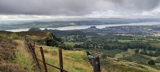
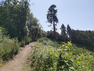
Where is it? This trail run or walk is located just outside Dumbarton at Overtoun house , overlooking the river Clyde. The run up to the top of Doughnot hill can be steep and muddy in places, but it does have a great crag top run overlooking the town and Dumbarton castle.  The Route Overtoun House - Map Park at the carpark of the house, from there the run starts heading back down Milton Brae towards the main road. Once past Loch Bowie take the next left on the farm track that leads to the quarry. You can't run through the quarry site. Instead you can run around the perimeter, which has been sign posted. This can be quite mucky in places and the track is only a couple of meters wide.  Loch Bowie Sign Post Alternative track around quarry After the run around the quarry the track leads back to a forestry track, which ascends  up to the Black Linn Reservoir. Head north west beyond the reservoir up to the top of Doughnot hill. There is a trig point at the top so should be easy...

Green Bridge Run

Image
There are many walks or runs that can be done at Chatelherault Country Park, just outside Hamilton.  One of those is the Green bridge walk, a 7km track that heads south east along the river Avon Water. I decided to run this route, having walked it on previous occasions.  The track is mostly tree lined for the first 4.5km. The track before reaching the turn for the Green bridge is mostly level, it then descends down to the fine wooden bridge with good views across the Avon water.  Avon Water Sign The Green Bridge Time to rest The track after the bridge ascends rapidly and I was forced to walk this section of the run. As the track evens out there is a chance of a nice viewpoint, however it isn't too well marked and can be easily missed. You get the full effect of the weather on the west side of the Avon water as the tree line has been cut back, giving less protection.  There is a chance to visit the Cadzow Oaks, trees which are over 700 years old. You can hav...

Ben Dubh

Image
  Location   Ben Dubh is located at Luss at Loch Lomond about an hour drive from Glasgow on the A82. The Route The Route From the car park at Luss, head up School Road, it looks like a side street and has the Signpost for Glen Luss. The will take you to the Bridge over the A82. Once over, continue past the house and take the next left at the corner you will see the Signpost for Ben Dubh and a gate. Go through the gate and follow the path through the ferns.    Glen Luss sign Hill Sign Hill Track The walk leads through a wooded area before opening out onto open ground where you get a better look at the Hill. The path continues north west for 4km, there are a few false tops before you reach the cairn at the summit.  Obvious Path Getting There  The Path Up.  The Top It took just over an hour to reach the summit with the 3 older children. They all managed it, even though the youngest (7) found the track a bit of a slog.  The weather had been so dry dur...

Scotland's Highest Village

Image
  Lowther Hill Radar Station Wanlockhead has the distinction of being the highest highest village in Scotland at 466m and located here are the Lowther hills. Lowther and Green Lowther hills can be spotted easily due to the radar station and aerials that are situated at the tops of these hills.  Wanlockhead Route  The Route  We  parked at the Visitor centre car park. From there we walked past the toilets, up the slope next to the playpark. We continued this across the road and up onto the open slopes, heading south east.  We were following part of the route for the Southern Upland Way, the markers were quite obvious.  Wanlockhead Village Route Markers for the SUW The track crosses over the road that leads up to the radar station and it would be possible to walk entirely on the road. The height of Lowther Hill is 725m so the accent from the village is only just under 300m.  Looking Back Down the Track Getting Closer  Road to the Station  V...

A Long Hike

Image
Beinn a'Chreachain and Beinn Achaladair Beinn a'Chreachain Beinn Achaladair  Starting Point. These two munros sit just few miles north east of the Bridge of Orchy. Turn off the A82 at the Achalladar Farm, the sizable car park is situated close to the main road.  Route The Route From the car park head along the track to Achalladar Farm, go past the farm alongside the field and follow the path next to the river. Continue along, past the old wooden bridge to the forest.  Old Wooden Bridge I turned up through the forest too early. I did find wooden signposts later on but it is best to continue alongside the forest until you find a sign. I made my way up through the woods to the railway line. The ground here was wet and quite boggy in places. At this point I still had trouble finding the Bridge over the railway line. I finally came across it further down, obviously I had thought I was further along on the map than I was. Once over the bridge, I picked up the signposts and cont...