Posts

Showing posts from December, 2021

Beat the Street

Image
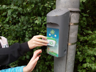
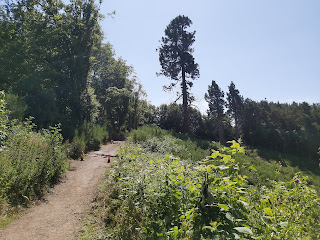
  For 6 weeks between September and October the Beat the Street game was installed in our local neighbourhood. This gave children and adults alike a chance to participate, a different take on staying healthy. The idea is simple, there was over 60 boxes in a local area  scanning a box with a special cards or fob that gives you 10 points towards your overall amount. There were different events during this time that gave double or even triple points. The rules were simple, you can walk, run or cycle between boxes,travelling by car was against the rules.  Halloween themed boxes The benefit was that it got me motivated to run in the local area, something I didn't like usually doing. It also allowed you to meet other people that was taking part. It was fun to see those that took the game seriously. Once I got into, it my aim was to break into the top 100 players. I managed this and was able to sneak into the top 50, finishing at 49 out of over 7000 players.  Leader board  Badges

Doughnot Hill

Image
Where is it? This trail run or walk is located just outside Dumbarton at Overtoun house , overlooking the river Clyde. The run up to the top of Doughnot hill can be steep and muddy in places, but it does have a great crag top run overlooking the town and Dumbarton castle.  The Route Overtoun House - Map Park at the carpark of the house, from there the run starts heading back down Milton Brae towards the main road. Once past Loch Bowie take the next left on the farm track that leads to the quarry. You can't run through the quarry site. Instead you can run around the perimeter, which has been sign posted. This can be quite mucky in places and the track is only a couple of meters wide.  Loch Bowie Sign Post Alternative track around quarry After the run around the quarry the track leads back to a forestry track, which ascends  up to the Black Linn Reservoir. Head north west beyond the reservoir up to the top of Doughnot hill. There is a trig point at the top so should be easy to spot,

Green Bridge Run

Image
There are many walks or runs that can be done at Chatelherault Country Park, just outside Hamilton.  One of those is the Green bridge walk, a 7km track that heads south east along the river Avon Water. I decided to run this route, having walked it on previous occasions.  The track is mostly tree lined for the first 4.5km. The track before reaching the turn for the Green bridge is mostly level, it then descends down to the fine wooden bridge with good views across the Avon water.  Avon Water Sign The Green Bridge Time to rest The track after the bridge ascends rapidly and I was forced to walk this section of the run. As the track evens out there is a chance of a nice viewpoint, however it isn't too well marked and can be easily missed. You get the full effect of the weather on the west side of the Avon water as the tree line has been cut back, giving less protection.  There is a chance to visit the Cadzow Oaks, trees which are over 700 years old. You can have a longer run by heading