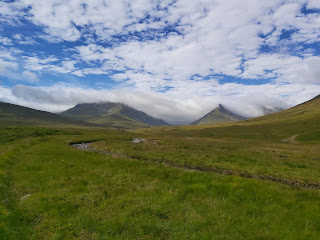
Beinn a'Chreachain and Beinn Achaladair
 |
| Beinn a'Chreachain |
 |
| Beinn Achaladair |
Starting Point.
These two munros sit just few miles north east of the Bridge of Orchy. Turn off the A82 at the Achalladar Farm, the sizable car park is situated close to the main road.
Route
 |
| The Route |
From the car park head along the track to Achalladar Farm, go past the farm alongside the field and follow the path next to the river. Continue along, past the old wooden bridge to the forest.
 |
Old Wooden Bridge
|
I turned up through the forest too early. I did find wooden signposts later on but it is best to continue alongside the forest until you find a sign. I made my way up through the woods to the railway line. The ground here was wet and quite boggy in places. At this point I still had trouble finding the Bridge over the railway line. I finally came across it further down, obviously I had thought I was further along on the map than I was. Once over the bridge, I picked up the signposts and continued to make my way through the forest. The signs pointed over a stile through a fenced off area. I decided to walk up and around the outside of this. I walked north east to the Allt Coire an Lochain burn and from there picked up the track south east to the Lochain a Chreachain.
 |
| Slow Going in the Forest |
 |
| Signpost |
 |
| Track to the Lochain |
 |
| Lochain a Chreachain |
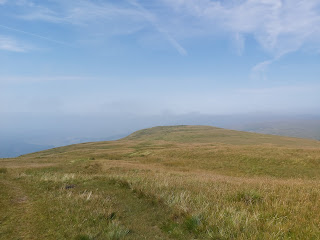
From the Lochain I headed east up the slope to the ridge just below the summit of Beinn a'Chreachain. There is a track here but it can be tricky to find. The track along the ridge to the summit is much clearer and isn't far once you have made it to the ridge.
 |
| Ridge to the Summit |
 |
| Summit of Beinn a'Chreachain |
The time taken for this first Munro was 3hr 50mins and the summit height was 1081m. From this summit I followed the ridge line west of Meall Buidhe, following the track that skirts below the top of this ridge. This drops down to 813m before ascending again to Beinn Achaladair. The climb to the top of this Munro is steep in parts and does call for some very basic scrambling over some large rocks. Please note that this could be dangerous in wet or icy conditions. It took 1hr and 10mins to reach the summit of Beinn Achaladair at 1038m. Again, the cairn is very close to the edge of the Munro top so be careful. On a clear day you can see the Munros into Glencoe and the car park that you parked in!
 |
| Track under Meall Bhuide |
 |
| Looking at Beinn Achaladair |
 |
| A Steep Climb |
 |
| Summit of Beinn Achaladair |
Instead of following the same path back, I continued along the Beinn Achaladair ridge which took me down to the Bealach next to Beinn an Dothaidh. I followed the track back down the river Allt Corie Achaladair. This weaves back and forth over the river, easy to do since the weather has been so dry, but could cause issues after heavy rainfall. The walk back to the car from the bealach is about 2.5km and the walk from the summit of Beinn Achaladair back to the car park took over 2 hours to complete.
These two Munros are worth doing and give great views of a range of other mountains in the area. The walk up can be tricky at times, especially through the forest. The overall route distance was just under 23km so plan this as an all day event but overall you won't be disappointed with the walk up to these Munros.
For more information check this link


Comments
Post a Comment