Back to Basics
After 20 years walking and hiking outdoors it was time to improve on my map reading and compass skills. To be fair my map reading skills were decent enough and I can pinpoint where I am on a hill quite accurately on a OS map. There are times were I have gotten things wrong, mostly because of the poor weather and visibility, but I've always managed to find my way back. My compass skills however are, to put it bluntly, not very good. This is an area I know I should improve on. So the opportunity arose to take part in a walk in the Pentlands, just outside Edinburgh, that work work on my map and compass skills.
Starting Point
 |
| Route |
The walk began at Threipmuir Reservoir car park, just outside the small town of Balerno. The car park is a decent size but can fill up quickly. Although the car park is free there is a suggested donation of £2.
 |
| Elevation Profile |
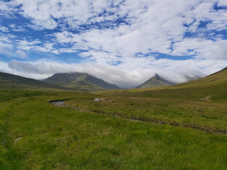
From the car park, we walked down the single track road to a bridge that crosses Threipmuir reservior and up the hill. At the top, we took a right and accessed a gate that takes you up a newly built path hill track. We got a decent view of Hare Hill. Once through the next gate at the top of the path, we took a left, heading east, and skirted along the base of the hill towards the waterfalls. There were decent views of Black hill as well as West and East Kip. These hills are easily accessible from the reservoir car park and would make for a nice day's walk.
 |
| Cloud around East Kip |
 |
| Waterfalls |
 |
| Cottage Before Loganlea Reservoir |
 |
| Loganlea Reservoir |
 |
| Looking Back Down Logan Cottage |
The track descended to the waterfalls and also gives access to tracks back up to the Kip hills and Scald Law. We followed the track past Loganlea reservoir until Logan Cottage.
We accessed the cottages drive way and walked right, away from the property and climbed over another gate. From here we followed a track on a bearing of 290 degrees which followed the base of Black hill. Once at the boundary wall we continued on a bearing of 253 degrees to the pump house at Threipmuir reservoir. From here we followed the reservoir back to the car park.
 |
| Threipmuir Reservoir |
 |
| Looking towards Harlaw Reservoir |
Distance Walked: 13km
Time Taken: 4 hours
Highest Point: 443m


Comments
Post a Comment