Gleniffer Braes Country Park
Hiking with kids
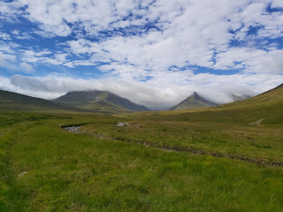
What do you do on your birthday? Some people like to celebrate with a party or a meal. My choice has always to go for a hike or a walk somewhere. So this year I decided to choose Gleniffer Braes Country Park. This park is located just outside of Paisley, near Barrhead. We actually parked at the car park at the furthest end, next to the information hut. The idea was to walk the Tannahill walkway which would take in the impressive Craigie Linn waterfall and the viewpoint over looking the surrounding area.
The Route
From the car park we headed along the path that wound up through the woods. We had managed to get a map from the information hut and that helped to navigate our way. The first stop was to walk to the waterfall. The weather in Scotland had been mixed, very warm with large downpours of rain. Our way to the waterfall only took about 20 minutes, it took us up some large wooden steps. There is a signpost and this leads you down more wooden steps to the waterfall. The Craigie Linn as it is known is 8m in height, it was as I had hoped, a powerful waterfall which even the locals had said was the best they had seen.
We doubled back up there steep steps and from the waterfall filled there path east. We followed signs for there Robertson Car park, also known as the car park in the sky. A car park perched up in which to command the views over the local area. Or aim was simple, find somewhere to stop to eat. The wooded path was gloriously cool and the light filters through the leaves hanging on the trees.
 |
| Car Park in the Sky |
 |
| A Walk in the Woods |
 |
| More Woods |
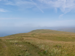
Finally the woodland ends and you cross over to open hillside, that has some lovely views of Paisley and the surrounding area. The track stays consistent throughout the walk, wide and sturdy. It ascends slightly and curves around to the left. There are a few benches placed to give people a chance to rest and take in the view. We had some lunch before our final short walk to the top.
 |
| Paisley |
 |
| On to the viewpoint |
 |
| View of the surrounding area |
 |
| Lunch |
 |
| Viewpoint |
We basically followed the same route back to the car, well almost. We took a parallel path on the opposite side of the waterfall which gave a different perspective on it. It would also be a good location to take some long distance photos of it.
 |
| Another Sign |
 |
| More Steps |
 |
| The Walk Back to the Car |
Total Distance Walked: 4.9 km/3 miles
Time Taken: 2h and 13mins


This comment has been removed by the author.
ReplyDelete
ReplyDeleteInstalling a Commercial EV charger installation at your facility can significantly benefit both businesses and the environment. By providing a reliable, eco-friendly charging solution for electric vehicles, businesses help reduce emissions while meeting the growing demand for sustainable transportation options. Not only does this improve your company’s environmental footprint, but it also attracts eco-conscious customers and employees. Moreover, offering Commercial EV charger installation enhances the convenience for users, encouraging longer stays and repeat visits. El Monde’s tailored installation services ensure a seamless process, making it easier to transition to greener energy sources.
Роскошные аксессуары подчёркивают статус и индивидуальность, создавая завершённый образ для тех, кто ценит качество. Именно ремень эксклюзив Royal Belts становится главным акцентом стиля, сочетая натуральную кожу и безупречную отделку. Каждую модель дополняет дорогая пряжка, подчёркивающая премиальный характер и уникальность изделия.
ReplyDelete