Croy to Falkirk
How to Get There
There is a regular train service from Glasgow Queen Street to Croy, which takes just under an hour. From the train station there is a short walk of about a mile to the start of this section of the John Muir Way.
 |
| Where to Start |
The Route
 |
| My Route |
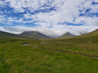
The start point can be found at Nethercroy road, situated there is a car wash and a takeaway shop. From there the path bends to the right and up through a narrow track to the start of Croy Hill. I have a previous post on this, which can be found on the blog. Croy hill is only 147m in height and this only takes less than 10 minutes to reach the top. It is best to stay at the left hand side of the route, this is closest to the edge of the hill which overlooks the quarry. From here the path winds down through open fields and signs explaining more about the roman fort. The track eventually leads down though a track towards the main road and the familiar look of the canal.
 |
| Heading up Croy Hill |
 |
| The First of Many Tree Images |
The Canal Track
The track along the canal will eventually leads you to Bonnybridge. The worry was that the rest of the walk to Falkirk would be along the canal path, however it is only about 4 miles. The canal path can be a welcome sight as the flat path is easy to walk on although this can get boring. There is not much to say here other than there is a small house, situated at one of the locks that you can buy eggs from. It would be an idea as a challenge to eat locally produced food when undertaking one of these hikes.
 |
| The Canal |
 |
| Looking Back At the Road |
 |
| The Tunnel at Bonnybridge |
The canal path leads to Bonnybridge where there are shops and places to eat. The path leads you over a bridge over the canal. The next section starts across the road next to a Auto Repair Centre. I missed this and walked further on to the main junction before it dawned on me that I was walking the wrong way. The route takes you parallel to the canal but through a small housing and industrial estate. Follow this for a mile or so before the path takes you on a bridge over the railway line. From here walk up the farm track for half a mile before you reach the next Roman fort, which is Roughcastle.
Roughcastle Fort
Another walk on the John Muir Way and another Roman Fort to discover. These discoveries are becoming the highlight of these walks as they tend to be in large open grassy areas that are a joy to explore. These areas are also in stark contrast to the linear canal or road walking that is also part of the JMW. As you can see from some of the images, you could easily spend some time here relaxing under one of the large trees, having a bite to eat. The path leads you down towards the train line and a woodland walk towards the Union canal and the Falkirk Wheel.
 |
| Roughcastle Fort |
 |
| Trees |
The Falkirk Wheel
 |
| Falkirk Wheel and Visitor Centre |
 |
| Typical Signs |
It is only a mile or two from Roughcastle to the Falkirk Wheel and in that time you can see glimpses of the top of the wheel. The Wheel is used to move canal boats from the upper part of the canal to the lower level, a feat of engineering is what it has been described as. I wasn't sure if the track would lead me there, or if it would miss it completely, but it does bring you to the top end of the area. There is a visitors centre here and other amenities like toilets etc. However, I was heading on; the track bends up so that you can see what the wheel looks like from the top level. Thinking about it now I should have waited to get a video of the wheel in motion. At this point thoughts turned back to the walk. I assumed that I would be following the canal path again, however the John Muir Way disappears into the woods briefly before reappearing at the start of a housing estate. the route then dinks it way behind a set of high rise buildings, over a railway track, again, and over the canal - again!
 |
| Woodland Path After Falkirk Wheel |
The Battle of Falkirk
 |
| Monument |
 |
| Sign Depicting The Battle of Falkirk |
The last part of my walk was spent in lovely woodlands reading interesting facts about the area and wildlife from magnificent signposts. Part of this walk was also mixed with a local walk commemorating the Battle of Falkirk, between the Jacobite and government armies. The sign posts dried up a little around this part of the walk and I had to consult the map to make sure I was heading in the correct direction. It would be worth revisiting this site as it provides good information about the history of the area and a lovely walk to boot.
Eventually the walk brought me back to the canal for a brief stint before reaching Falkirk High train station where my day ended, well not quite. I walked a little father to find my family having fun in Calendar Park, but I'll be back to walk the next section to Linlithgow next week.
 |
| Tunnel to Train Station |


Comments
Post a Comment